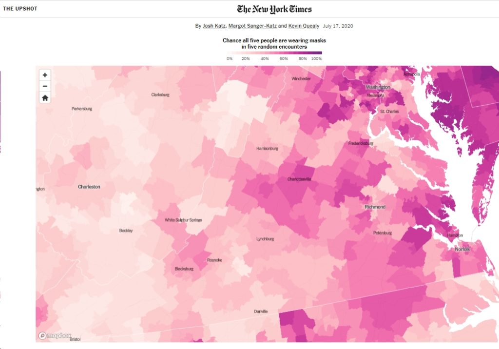
The NY Times has a “detailed map of who is wearing masks in the U.S.” – including here in Virginia. See below for the Virginia map (click to enlarge). Also, here are a few things that jumped out at me.
- As is the case in the country as a whole, here in Virginia it certainly looks like this: “In some American neighborhoods, it’s hard to spot even one person outside without a face covering. In others, your odds of seeing many maskless people are quite high.”
- As the NY Times reports – “Mask wearing is common among Americans of both political parties, but there is a 20-point split in many surveys, with Republicans substantially less likely to say they wear masks often or always and much more likely to say they never wear a face covering...partisanship is the big determinant of all of the behavior.” And you can definitely see that in the Virginia map, with “bluer” areas of the state tending to have higher percentages of mask usage, and “redder” areas having lower – even very low – percentages.
- “But,” as the NY Times reports, “that doesn’t mean that politics is the only factor that matters. Our map shows low mask use in several rural parts of the country with very few coronavirus cases.” And you can see that on the Virginia map as well, with rural areas tending to have lower percentages of mask usage, and urban/suburban areas having higher percentages. Of course, rural areas also tend to be “red” politically, while urban/suburban areas tend to be “blue.”
- For instance, if you look at “blue” and urban/suburban northern Virginia, you’ll see a lot of places where “always” mask usages is in the 70%’s or 80%’s. But you’ll also see a few spots in northern Virginia, such as in western Alexandria and eastern Fairfax, where “always” percentages drop off into the 60%’s. I’m not sure why that is, exactly.
- You can also see high “always” percentages around Charlottesville, Fredericksburg, Hampton, Norfolk, Richmond and Roanoke City. “Always” percentages are relatively low around Harrisonburg, around Lynchburg, in much of Southside Virginia, and in Southwest Virginia – as low as the upper 20%’s and 30%’s in some spots north of Bristol (e.g., Scott, Russell, Washington counties…).
What else jumps out at you?