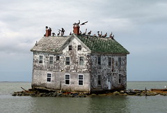
 Sea levels have already risen 8 inches since 1880 and thanks to global warming are forecast to rise at least several more feet in the lifetime of a child born today. A new study from Climate Central takes a look at what that means for people who live on America’s coasts:
The studies look at people who live in homes within three feet of high tide, whereas old studies looked just at elevation above sea level, according to work published in the peer-reviewed journal Environmental Research and an accompanying report by Climate Central.
That’s an important distinction because using high tide is more accurate for flooding impacts, said study co-author Jonathan Overpeck, a scientist at the University of Arizona’s Institute of the Environment. And when the new way of looking at risk is factored in, the outlook looks worse, Overpeck said.
“It’s shocking to see how large the impacts could be, particularly in southern Florida and Louisiana, but much of the coastal U.S. will share in the serious pain,” Overpeck said.
And what about here in Virginia? I entered a very modest number – three feet of sea level rise, storm surge & tide – into the ClimateCentral.org model & here’s what I got:
Things below +3ft in Virginia:
- Population 58,507 0.7%
- Homes 28,511 0.8%
- Acres 157,123 0.6%
Over 1 in 6 chance sea level rise + storm surge + tide will overtop +3ft by 2020 at nearest flood risk indicator site: Lewisetta – Potomac River.
View the model for yourself and see what different levels of sea level rise would mean for your community at ClimateCentral.org.
Cross-posted from The Green Miles


![Sunday News: “Trump Is Briefed on Options for Striking Iran as Protests Continue”; “Trump and Vance Are Fanning the Flames. Again”; “Shooting death of [Renee Good] matters to all of us”; “Fascism or freedom? The choice is yours”](https://bluevirginia.us/wp-content/uploads/2026/01/montage011126.jpg)

![VA DEQ: “pollution from data centers currently makes up a very small but growing percentage of the [NoVA] region’s most harmful air emissions, including CO, NOx and PM2.5”](https://bluevirginia.us/wp-content/uploads/2026/01/noxdatacenters.jpg)
![New Year’s Day 2026 News: Full Video of Jack Smith Testimony – “The attack that happened at the Capitol…does not happen without [Trump]”; Trump/RFK Jr Make Measles Great Again; Right-Wing YouTuber Nick Shirley Definitely Not a Real Journalist; Musk Did Enormous Damage in 2025](https://bluevirginia.us/wp-content/uploads/2026/01/montage010126.jpg)


